❌

Reading view

Pre-Existing Structure and Stress Shape Geothermal-Induced Seismicity

Map of the study region and 2 graphs from the study.
Editors’ Highlights are summaries of recent papers by AGU’s journal editors.
Source: Journal of Geophysical Research: Solid Earth

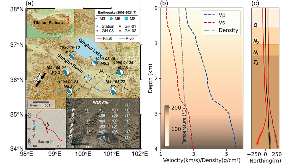
Enhanced Geothermal Systems (EGS) can expand low-carbon energy production, but fluid injection may trigger earthquakes whose locations and mechanisms are difficult to predict. Feng et al. [2026] investigate induced seismicity at China’s first EGS site in the Gonghe Basin using a comprehensive observational dataset. Machine learning processing of data from 20 surface seismic stations produced a high-resolution earthquake catalog with well-constrained locations and focal mechanisms. Stress inversion and modeling, constrained by borehole stress measurements, reveal mechanically weak faults with low friction coefficients, indicating that low-to-moderate fluid overpressure can trigger seismic slip. Site-scale analysis shows that seismicity reflects shear reactivation of pre-existing natural faults, rather than the creation of new tensile fractures. Further integration with borehole image logs reveals a fine-scale relationship between the main seismogenic zones and stress heterogeneity, expressed as rotations of the principal stress axes that likely reflect localized lithological contrasts and fault-damage zones.

Together, these integrated analyses show that geothermal-induced seismicity is controlled by inherited fault architecture at the site scale and localized stress heterogeneity at the borehole scale. By linking seismic observations to borehole stress and image-log evidence, the study provides a more physically constrained framework for seismic-hazard assessment and stimulation design in enhanced geothermal reservoirs.

Citation: Feng, P., Wang, R., Zhang, H., Zhang, C., Schultz, R., & Yang, L. (2026). Pre-existing structures and stress variations jointly control the induced seismicity in enhanced geothermal system of Gonghe Basin, China. Journal of Geophysical Research: Solid Earth, 131, e2025JB033158. https://doi.org/10.1029/2025JB033158β€―Β 

β€”Xiaowei Chen, Associate Editor, JGR: Solid Earth

Text Β© 2026. The authors.Β CC BY-NC-ND 3.0
Except where otherwise noted, images are subject to copyright. Any reuse without express permission from the copyright owner is prohibited.
  •  

From Grains to Bands: Modeling Deformation in Porous Rocks

Photo of a rock outcrop.
Editors’ Highlights are summaries of recent papers by AGU’s journal editors.
Source: Journal of Geophysical Research: Solid Earth

Highly porous rocks, such as sandstones, often deform in a surprising way: instead of breaking apart or sliding, they develop thin zones called deformation bands. In these bands, the grains are squeezed closer together, making the rock denser, and reducing how easily fluids such as water or oil can move through it. This behavior is important because it affects both the strength of rocks and their ability to store and transport fluids underground. However, these bands are difficult to model because they form suddenly from an initially uniform material and concentrate deformation into very narrow zones.

Wang etβ€―al. [2026] developed a computer modeling approach called a β€œphase‑field model” to study this process. Instead of drawing the bands in the initially homogeneous rock, the model allows them to appear naturally as the system evolves and minimizes its energy. The study shows how grain crushing and rearrangement allows the formation of localized deformation zones. The results also demonstrate that natural spatial variations in the rock, such as differences in grain size or porosity, strongly influence where bands initiate and how they grow. Additionally, the model captures how deformation changes from sliding (shear bands) to pure compaction as pressure increases. Overall, this work provides a realistic way to understand how localized deformation develops in rocks, with important implications for geology, engineering, and energy applications.

Citation: Wang, Y., Zhang, C., Braun, P., Kang, X., & Wu, W. (2026). How does heterogeneity control strain localization patterns in high-porosity rocks? Journal of Geophysical Research: Solid Earth, 131, e2025JB032494. https://doi.org/10.1029/2025JB032494

β€”FranΓ§ois Renard, Associate Editor, JGR: Solid Earth

Text Β© 2026. The authors.Β CC BY-NC-ND 3.0
Except where otherwise noted, images are subject to copyright. Any reuse without express permission from the copyright owner is prohibited.
  •  

Navigating the Past with Ancient Stone Compass Needles

A computer and keyboard on a desk sit next to a complex microscope that says β€œQDM” on the top.
Source: Journal of Geophysical Research: Solid Earth

Magnetic rocks with iron oxide concentrations act as natural chroniclers of Earth’s past continental movements. Using small samples of rocks, scientists can isolate magnetic grains that were frozen in orientation as the rock solidified. The magnetization of these grains acts as a miniature compass needle, pointing toward ancient magnetic poles. This same principle applies to extraterrestrial samples, such as meteorites and lunar rocks, which preserve evidence of the early solar nebula’s evolution.

However, traditional bottle cap–sized bulk samples often contain a mixture of reliable and unreliable magnetic signals, resulting in complex data that hamper interpretation. To improve accuracy, researchers have turned to magnetic microscopy. This technique maps magnetic fields at submillimeter to submicrometer scales in thinly sliced rock sections using advanced tools like a quantum diamond microscope (QDM) or a cryogenic superconducting quantum interference device microscope. By creating high-resolution maps of individual magnetic particles, scientists can reconstruct ancient fields with much higher precision while filtering out muddy signals from unstable grains.

Despite its potential, magnetic microscopy is an emerging field with its own set of uncertainties. To help constrain measurement data, Bellon et al. combined QDM observations with computer modeling to analyze how a magnetic particle’s stray fieldβ€”the magnetic flux that leaks into the surrounding spaceβ€”decays as it moves away from the source. They specifically investigated how a particle’s internal magnetic structure and external measurement noise affect the accuracy of these reconstructions.

The study found that in iron oxides, the smallest and most magnetically stable particles produce signals that are strong at the source but fade rapidly with distance. In contrast, larger particles produce signals that remain detectable farther away. This creates a challenge: The most stable grains for long-term geological data (the smallest ones) are the hardest to detect if the sensor is not perfectly positioned or if sensor interference is present.

By quantifying measurement error, the authors provide a road map for the field of micropaleomagnetism. Their findings could allow researchers to better account for uncertainty, leading to more robust reconstructions of Earth’s magnetic history and a deeper understanding of planetary evolution. (Journal of Geophysical Research: Solid Earth, https://doi.org/10.1029/2025JB033133, 2026)

β€”Aaron Sidder, Science Writer

A photo of a telescope array appears in a circle over a field of blue along with the Eos logo and the following text: Support Eos’s mission to broadly share science news and research. Below the text is a darker blue button that reads β€œdonate today.”
Citation:Β Sidder, A. (2026), Navigating the past with ancient stone compass needles,Β Eos, 107, https://doi.org/10.1029/2026EO260122. Published on 16 April 2026.
Text Β© 2026. AGU.Β CC BY-NC-ND 3.0
Except where otherwise noted, images are subject to copyright. Any reuse without express permission from the copyright owner is prohibited.
  •  
❌