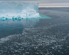
Exclusive A vast area of the Bellingshausen Sea should be covered by sea ice by now, with one expert calling the loss of ice ‘depressing’Antarctica’s west coast is missing an area of winter sea ice the size of France, sparking concerns for threatened penguins other marine life and global sea levels.One expert said the loss of ice in the Bellingshausen Sea was “depressing” and the failure of ice to form could have intensified a heatwave over the continent’s peninsula last week that saw daytime te
Exclusive A vast area of the Bellingshausen Sea should be covered by sea ice by now, with one expert calling the loss of ice ‘depressing’
Antarctica’s west coast is missing an area of winter sea ice the size of France, sparking concerns for threatened penguins other marine life and global sea levels.
One expert said the loss of ice in the Bellingshausen Sea was “depressing” and the failure of ice to form could have intensified a heatwave over the continent’s peninsula last week that saw daytime temperatures peak at 15.4C which is more than 20C above average.
clgkhkrf54 posted a photo:
Maya Classic Period (550-900 AD) rare polychrome pottery from the Jay I. Kislak collection, Library of Congress, Geography and Map Division. See long file names for additional information.
Maya Classic Period (550-900 AD) rare polychrome pottery from the Jay I. Kislak collection, Library of Congress, Geography and Map Division. See long file names for additional information.
Source: Geochemistry, Geophysics, Geosystems
About 600 million years ago, the continents wandered Earth, yet to settle into their current positions. Their locations during the Ediacaran (as this time is called) have been tough for scientists to pin down. Earth’s magnetic field appears to have behaved in erratic ways, and applying standard techniques to calculate the continents’ positions based on records of the magnetic field yields implausible results. In particular, scientists debate the l
About 600 million years ago, the continents wandered Earth, yet to settle into their current positions. Their locations during the Ediacaran (as this time is called) have been tough for scientists to pin down. Earth’s magnetic field appears to have behaved in erratic ways, and applying standard techniques to calculate the continents’ positions based on records of the magnetic field yields implausible results. In particular, scientists debate the location of an ancient continent called Baltica, which is now part of Europe.
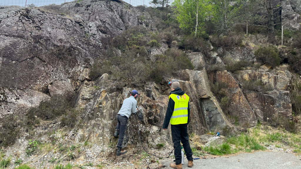
To investigate, Xue et al. traveled to Egersund, Norway, to collect samples of rock that formed during a time when Baltica’s crust was being pulled apart, allowing magma to percolate up from below. As that magma hardened, it recorded snapshots of Earth’s magnetic field, storing information about Baltica’s position in the process.
The results of studying these samples revealed a much more complex picture of the ancient rocks than the scientists initially envisioned. The rocks contained a messy mix of at least six magnetic signals. Several appeared to have formed when more modern geological processes altered the original rocks. Three distinct signals may have survived from the Ediacaran period, two of which diverge from the most plausible Ediacaran signal, which places Baltica near the equator. These conflicting signals further support the idea that Earth’s magnetic field was behaving strangely at the time, adding new complexity to an already puzzling picture.
On the basis of the new results, the researchers place the Egersund paleomagnetic pole at 20.8°N, 89.0°E during the Ediacaran—which diverges from previous results—and suggest that Baltica was located near the equator, adjacent to the ancient continent Laurentia, but rotated slightly clockwise relative to previous reconstructions. The study demonstrates the convoluted nature of the magnetic signals preserved in ancient rocks and the importance of dissecting those records into their constituent components. Doing so, the researchers suggest, can shed new light on the enigmatic behavior of Earth’s magnetic field during the Ediacaran. (Geochemistry, Geophysics, Geosystems, https://doi.org/10.1029/2025GC012730, 2026)
clgkhkrf54 posted a photo:
Maya Classic Period (550-900 AD) rare polychrome pottery from the Jay I. Kislak collection, Library of Congress, Geography and Map Division. See long file names for additional information.
Maya Classic Period (550-900 AD) rare polychrome pottery from the Jay I. Kislak collection, Library of Congress, Geography and Map Division. See long file names for additional information.
Planting more trees will decelerate climate change only if those trees are placed in optimal locations—primarily the tropics and subtropics—suggests new research published in Communications Earth and Environment. However, planting trees in locations like Alaska, Siberia, and large parts of the United States could actually lead to warming, said lead author and doctoral student at ETH Zurich Nora Fahrenbach.
Much of the current thinking in nature-based solutions, Fahrenbach said, is ba
Planting more trees will decelerate climate change only if those trees are placed in optimal locations—primarily the tropics and subtropics—suggests new research published in Communications Earth and Environment. However, planting trees in locations like Alaska, Siberia, and large parts of the United States could actually lead to warming, said lead author and doctoral student at ETH Zurich Nora Fahrenbach.
Much of the current thinking in nature-based solutions, Fahrenbach said, is based on the idea that “more is better.”
As in, “we’ll plant a trillion trees, or we’ll plant more than a trillion trees, and we are going to get more cooling, right?” Fahrenbach said. “That’s something we show is just not the case.”
Fahrenbach researches reforestation potentials, or global maps that identify areas where trees could be planted to mitigate climate change. In this work, she and her colleagues compared three prominent reforestation potentials to determine the effect of tree placement on local and global temperatures.
One scenario involved reforesting about 926 million hectares focused mostly on the tropics and resulted in about 0.25°C of cooling by 2100. Another called for reforesting 894 million hectares, including large areas in northern temperate and polar latitudes, and resulted in 0.13°C of cooling by 2100.
The third scenario involved planting forests strategically over only 440 million hectares of mostly tropical and subtropical land (less than half of the area covered in the other scenarios) but also resulted in 0.13°C of cooling. Geography, the findings suggest, may matter more than quantity when it comes to the cooling benefits of reforestation efforts.
Let’s Get (Biogeo)physical
The researchers modeled all three scenarios using the same parameters: Trees were planted from 2015 to 2070 and then remained steady in their population until 2100.
Planting trees in one area doesn’t just change the local temperature but has effects across the world.
All three models identified reforestation opportunities in regions such as the eastern United States, Amazonia, the Congo rainforest, and eastern China, as well as regions for which reforestation would not be as impactful, such as polar regions in the Northern Hemisphere. The researchers also found significant temperature changes across the Atlantic and Indian oceans as a result of atmospheric changes induced by reforestation, demonstrating an interconnected reality: Planting trees in one area doesn’t just change the local temperature but has effects across the world.
These local and nonlocal effects can be explained by a combination of biogeochemical and biogeophysical effects.
A biogeochemical effect relates to the movement of chemicals or chemical elements, such as trees absorbing carbon from the atmosphere.
A biogeophysical effect relates to the physical results of changing the land’s surface: Placing a tree in a snowy region, for instance, decreases the land’s albedo, meaning it causes the land surface to become darker and absorb more light, leading to more local heat. This rise in surface temperature also raises air temperature, creating cascading effects on wind patterns and oceanic currents.
Considering both processes together is essential for understanding whether a net cooling or net heating effect exists, but most policies focus only on biogeochemical effects, seeing trees solely for their ability to absorb carbon from the atmosphere, Fahrenbach said. They include prominent international policies such as the Paris Agreement and the United Nations’ Framework for REDD+.
“Really, we would also need to consider the biogeophysical effects,” Fahrenbach said. “That’s harder to do, right, considering those nonlocal effects, because just imagine, some country is going to plant a lot of trees, and that’s going to lead to warming somewhere else.”
A Call to Policymakers
Emilio Vilanova, a forest ecologist at the climate action nonprofit Verra, wrote by email, “The most important message for me is that this study emphasizes something that is often not well addressed in reforestation projects: Reforestation is not just about planting trees—it’s about designing where new forests go to maximize benefits and avoid unintended consequences.”
“Reforestation is a helpful tool, not a stand-alone solution to climate change.”
Vilanova also said the study puts the potential for reforestation efforts to address climate change in perspective. “Even very large reforestation efforts would only reduce global temperatures by about 0.13–0.25°C by the end of the century,” he said. “While meaningful, this finding also reinforces that reforestation is a helpful tool, not a stand-alone solution to climate change.”
Though the limited potential for change is sobering, the authors and Vilanova pointed out that this change does matter and that it matters how we think of our approach. They advocate for policies that adopt reforestation strategies based on location and that acknowledge both the local and nonlocal effects of reforestation.
“We really need to make sure that where we plant first, it has benefits locally, it has benefits globally,” Fahrenbach said.
22 April 2026: This article was updated to correct Nora Fahrenbach’s position at ETH Zurich.
This news article is included in our ENGAGE resource for educators seeking science news for their classroom lessons. Browse all ENGAGE articles, and share with your fellow educators how you integrated the article into an activity in the comments section below.
Citation: Meissen, A. (2026), Location, location, location: The “where” of reforestation may matter more than the extent, Eos, 107, https://doi.org/10.1029/2026EO260125. Published on 22 April 2026.
Source: Geochemistry, Geophysics, Geosystems
This is an authorized translation of an Eos article. 本文是Eos文章的授权翻译。
大约 6 亿年前,各大洲在地球上漂移,尚未最终定格在现在的位置。在埃迪卡拉纪时期,各大洲的位置对于科学家来说一直难以确定。地球的磁场似乎表现得异常不稳定,而利用标准方法根据磁场记录来计算大陆位置的做法却得出了一些难以置信的结果。尤其是,科学家们对一块名为波罗的大陆的古老大陆的位置存在争议,这块大陆如今是欧洲的一部分。
为了探究这一问题,Xue等人前往挪威埃格尔松德,采集了波罗的大陆地壳被撕裂、岩浆从下方涌出时形成的岩石样本。随着这些岩浆冷却凝固,它们记录了地球磁场的瞬时变化,并在此过程中存储了有关波罗的大陆位置的信息。
对这些样本的研究结果揭示了远比科学家们最初设想的更为复杂的古代岩石图景。这些岩石中至少包含了六种不同的磁信号,构成了一幅复杂的混合图景。其中一些信号似乎是在更现代的地质过程改变原始岩石时形成的。埃迪卡拉纪时期可能保存了三种