When we picture the effects of melting glaciers, many of us think of rising seas and retreating ice streams. But along Greenland’s coastline, a quieter transformation is underway, one that is affecting how the ocean breathes and how it reacts to and buffers itself against change.
In Young Sound, a fjord carved into Greenland’s remote northeastern coast, decades of monitoring have revealed that glacial meltwater does not simply dilute the salt in seawater. As fresh water enters the ocean, it weakens the ocean’s natural chemical resistance to swings in acidity. This so-called buffering capacity keeps seawater pH in balance. The loss of buffering due to freshwater runoff leaves these coastal waters unusually sensitive to even small biological and environmental shifts.
Atmospheric warming is accelerating fastest in the Arctic, and with it come longer glacial melt seasons and increased freshwater runoff. The result is a coastal ocean that is both a frontline witness to climate change and a laboratory for understanding how the chemistry of the seas can change in unexpected ways.
The Ocean’s Chemical Safety Net
Seawater chemistry is naturally buffered by dissolved ions that act as chemical shock absorbers.
Globally, the ocean absorbs about a quarter of carbon dioxide (CO2) emissions each year. That uptake helps to slow climate change, but at a cost. The more CO2 that water absorbs, the more acidic it becomes. Thankfully, seawater chemistry is naturally buffered by dissolved ions—particularly carbonate, bicarbonate, and hydroxide—that act as chemical shock absorbers. These negatively charged ions, collectively called alkalinity, bind to the positive hydrogen ions released when carbonic acid forms, keeping the ocean’s pH relatively stable compared with the more variable conditions in freshwater rivers and lakes.
The polar oceans play a special role in this balance and in the global carbon cycle because cold waters at high latitudes take up carbon from the atmosphere faster than warm tropical waters. Yet these regions are also changing the most rapidly.
When Meltwater Meets the Sea
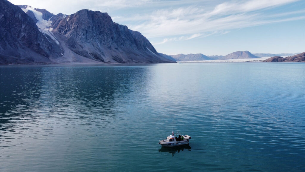
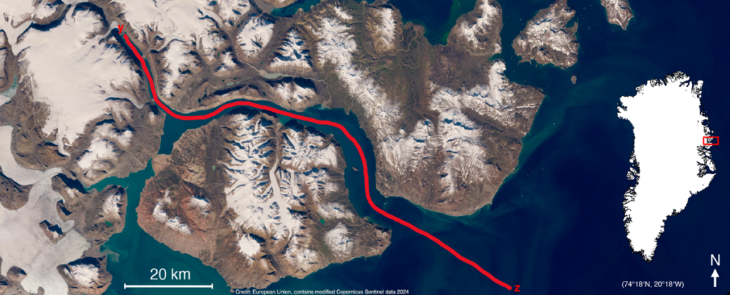
For 20 years, our team at Aarhus University has measured salinity, temperature, and carbon chemistry in Young Sound. Each August, we make the 2-day journey to northeast Greenland, where we spend the month sailing down the 90-kilometer-long fjord to capture these valuable measurements (Figure 1).
Fig. 1. The red line, running from the Greenland Ice Sheet (y) to the Greenland Sea (z), maps the route taken by researchers in August 2023 during their annual transect of Young Sound in northeast Greenland. Credit: Adapted from Henson et al., 2025, https://doi.org/10.1038/s43247-025-02685-4, CC BY-NC-ND 4.0
During the time we have monitored this ecosystem, the melt season has lengthened, with sea ice–free conditions now lasting 8 days longer than 20 years ago. Glaciers feeding the fjord are also thinning and retreating, discharging about 5.5 million cubic meters more water into the fjord each year. These changes have freshened the coastal ocean and subtly, but significantly, altered its chemistry.
Fjords like these have long been known as major CO2 sinks. Surface waters near glaciers often have very low CO2 concentrations, creating a disequilibrium between CO2 levels in the surface ocean and the atmosphere that draws carbon out of the air. But how or why these glacial ecosystems act as carbon sinks and what mechanisms are at play haven’t been thoroughly described. We have also been deeply curious about what else happens when fresh water enters the sea. What are the hidden consequences of this change?
To find out, we paired our long-term field observations with controlled lab experiments in which we mixed glacial meltwater with seawater. Controlled experiments allow us to dig into the nuances of chemical changes that are impossible to measure in the field. We also ran mixing models that allowed us to estimate how the chemistry of those mixed waters responds to small shifts in biological activity or mineral interactions.
The results were striking. When meltwater mixes with seawater, it not only reduces salinity but also dilutes alkalinity, the measure of how well water can neutralize acid and buffer against pH change. This weakening of buffering capacity means that even small changes in photosynthesis or respiration can drive much larger swings in CO2 uptake and acidity than they would in more saline waters.
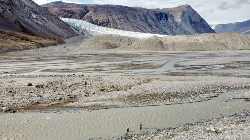
Two researchers wade into a meltwater river in Tyrolerfjord in Northeast Greenland National Park in 2023 to collect samples bearing the chemical fingerprints of climate change in the region. Credit: Henry C. Henson
We found that in the freshened waters of Young Sound, these processes have 2–3 times the influence on carbon uptake that they do farther out at sea. In effect, meltwater primes the coastal ocean to overreact, amplifying any ecosystem changes that might occur.
Measurements from around Greenland show that this is not just a theoretical risk. Surface waters are measurably more acidic where meltwater inputs are high. The biological consequences of this trend are still uncertain, but species living at the edge of their tolerance, such as shell-forming plankton and Arctic cod larvae, could face growing stress as the chemistry of their habitat fluctuates more widely.
A Fragile Balance in the Freshening Arctic
The findings confirm that fjords absorb carbon as a result of biological activity and glacial input but indicate that they do so in a fragile, easily tipped state.
Our study adds nuance to conventional perceptions of carbon cycling in fjords, long seen as places where atmospheric CO2 is drawn down. The findings confirm that fjords absorb carbon as a result of biological activity and glacial input but indicate that they do so in a fragile, easily tipped state. Slight shifts in the processes that pull CO2 out of the air could tip the scales in either direction: toward even more uptake and the accompanying acidification or toward a release of CO2 to the atmosphere.
This chemical sensitivity explains why Arctic fjords can show such strong seasonal and spatial swings in carbon chemistry and why predicting their long-term role in the carbon cycle is difficult. As glaciers retreat and meltwater inputs grow, those sensitivities are likely to intensify.
At first glance, changes in how seawater in the narrow, remote fjords of Greenland reacts to glacial melt might sound like a local concern. But the chemical processes at play have global resonance.
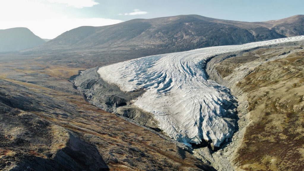
A tongue of the Greenland Ice Sheet retreats along the tundra as temperatures across the Arctic warm. Credit: Henry C. Henson
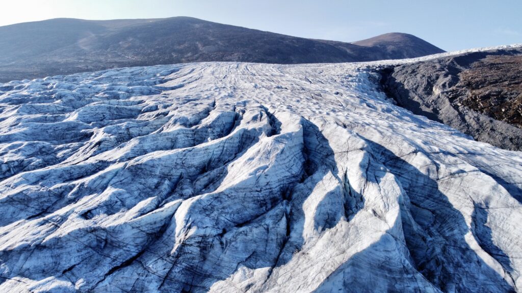
Ridges in the Greenland Ice Sheet tell a story of movement and melt. Credit: Henry C. Henson
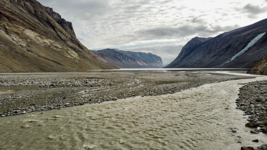
Glacial meltwater from the Greenland Ice sheet flows into Tyrolerfjord and Young Sound and in Northeast Greenland National Park in August 2023. Credit: Henry C. Henson
The Arctic Ocean as a whole is freshening, driven by accelerating ice melt as well as by increasing river discharge and changing weather bringing more precipitation to the region. Although river water, which arrives from the six great Arctic rivers of North America and Eurasia, is more alkaline than glacial melt, its alkalinity is only about half that of seawater. In other words, river runoff also increases the ocean’s chemical sensitivity. Fresh water also delivers organic matter from permafrost, fine sediments from glaciers, and tannin-rich runoff from tundra soils, each of which can influence carbon cycling and further compound changes already underway.
Similar patterns of increased rainfall and runoff reducing surface salinity are emerging around the Antarctic Peninsula, the Gulf of Alaska, and the North Atlantic. Almost everywhere that fresh water enters the ocean, it lowers alkalinity and limits the ocean’s ability to buffer change.
A Window into Climate Intervention
Our results also carry lessons for researchers and companies contemplating ocean chemistry interventions as ways to remove CO2 from the atmosphere. One proposed approach, ocean alkalinity enhancement, involves adding crushed minerals such as lime, olivine, and basalt to seawater to both counteract acidification and increase the ocean’s capacity to take up CO2.
Glacial systems already perform a natural version of this experiment by grinding rock into fine sediment and discharging it into the ocean. Minerals in this sediment react with seawater and shape its carbon chemistry.
Our study suggests that such reactions are especially potent in freshwater-influenced coastal regions, where reduced buffering capacity may amplify chemical responses not only from natural biological processes but also from potential human attempts to alter seawater chemistry. Thus, understanding the balance between carbon uptake and chemical vulnerability will be essential before any large-scale interventions are attempted.
Consequences Locally and Globally
Coastal communities from Greenland to Alaska to northern Eurasia depend on Arctic waters as part of their cultural identity and, by way of fisheries and tourism, for their economic and food security. As chemical buffering capacity declines, coastal ecosystems may become more susceptible to acidification and other environmental stresses. Small changes in temperature, ecosystem metabolism, or nutrient inputs could then have outsized effects on the marine life that supports these communities.
As coastal glaciers retreat and meltwater rivers carve new paths to the sea, they are doing more than raising sea level and reshaping coastlines. They are rewiring ocean chemistry.
At the same time, changing conditions in coastal Arctic ocean regions complicate scientific modeling of carbon cycling and climate feedbacks, which typically relies on averaged estimates of the ocean’s chemical reactivity. With meltwater making the coastal ocean more reactive, these seas may absorb or release CO2 more variably than how global predictions would suggest. In addition to the real effects on local ecosystems, seawater chemical variability could also affect the accuracy of modeled global carbon budgets, which we use to inform future climate projections and guide international policy goals.
As coastal glaciers retreat and meltwater rivers carve new paths to the sea, they are doing more than raising sea level and reshaping coastlines. They are rewiring ocean chemistry, leaving it fresher and more easily disturbed.
The chemical sensitivity we see in Greenland’s fjords today may be a preview of what is to come in many coastal regions. If so, then we must be concerned with not only how much CO2 the ocean can absorb but also how stably it can hold that CO2 in a rapidly changing world.
Author Information
Henry C. Henson (hch@ecos.au.dk), Aarhus University, Denmark
Citation: Henson, H. C. (2026), Melting glaciers make the coastal ocean more sensitive, Eos, 107, https://doi.org/10.1029/2026EO260116. Published on 16 April 2026.
Research & Developments is a blog for brief updates that provide context for the flurry of news that impacts science and scientists today.
In the contiguous United States, crop irrigation, municipal water supplies, and thermoelectric power generation use more than 224 billion gallons of fresh water every day. Conducting water research or making decisions about water use, until now, often required referencing datasets across various agencies. The U.S. Geological Survey (USGS) National Water Availability Assessment Data Companion (NWDC), announced this week, aims to streamline this process. In part, the tool is designed to help decisionmakers better understand the balance between how high demand and limited supply affect water availability in their communities.
“While the United States has abundant water nationally, regional imbalances between supply and demand may create water challenges affecting millions of Americans,” said lead scientist Shirley Leung in a USGSpress release. “What once required significant resources and time can now be done in minutes, giving communities of all sizes the same foundation for water planning.”
The lower 48 states are home to about 80,000 sub-watersheds, from those in the arid southwest to the Great Lakes Basin, where about 84% of North America’s surface fresh water is located. According to the USGS, the NWDC is the first tool that integrates information about water availability in individual watersheds at a national scale.
The tool is designed to complement Water Data for the Nation (WDFN), another USGS product that consolidates observational data from the agency’s thousands of local monitoring stations gathering data on streams, lakes, reservoirs, precipitation, water quality, and groundwater. The new tool uses modeling to fill in spatial and temporal gaps between the observations made at these stations.
Water managers, researchers, agricultural experts, and others can use the NWDC to compare watershed conditions, identify seasonal patterns in water use, or to create data visualizations of statewide water use, for example. Though the tool currently covers only the contiguous United States, it will soon be extended to Alaska, Hawaii, and Puerto Rico, according to the USGS.
David Tarboton, a professor of civil engineering at the Utah Water Research Laboratory, said he was “intrigued” by the new tool, and is interested in examining the data its model produces.
While Tarboton was disappointed that the tool’s most recent available data are from 2020, “having a sort of integrated, wall-to-wall dataset that’s consistently produced is very valuable,” he said. He works, in part, in the areas of hydroinformatics and data sharing, and noted that the modern methods the agency is using to share the data could be useful in developing automated tools.
These updates are made possible through information from the scientific community. Do you have a story about science or scientists? Send us a tip at eos@agu.org.
“Future winters promise less snow, more rain. Nobody’s prepared.” So proclaims the title of a recent article in the Proceedings of the National Academy of Sciences of the United States of America that frames adaptation to snow loss as the “million-dollar question” facing the western United States.
As the largest sectoral consumer of fresh water globally, agriculture is particularly vulnerable to snow loss.
Declining snowfall—and snowmelt—affects ecosystems, urban and rural water supplies, hydropower, recreation, tourism, and agriculture. As the largest sectoral consumer of fresh water globally, agriculture is particularly vulnerable to snow loss.
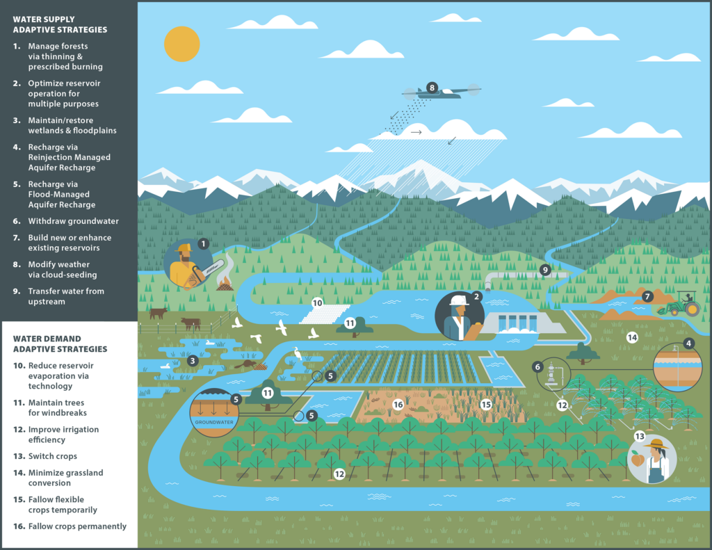
In response, water managers have developed a range of approaches for adapting to snow loss: infrastructure-based approaches like managed aquifer recharge, nature-based solutions such as forest management and beaver dam analogues, demand-side approaches like multibenefit land repurposing, and polarizing supply-side approaches like reservoir expansion and cloud seeding (Figure 1).
Fig. 1. Potential approaches to reduce negative impacts to agriculture from snow loss include a variety of adaptive strategies that address either water supply or demand. Click image for larger version.
However, efforts to identify which of these strategies to implement for different drainage basins, or watersheds, using the variety of available approaches seem to fall into one of two traps: either searching for unrealistic one-size-fits-all panaceas [Ostrom, 2007] or treating every basin as unique, which is costly and inefficient.
The “trillion-dollar question” isn’t how to adapt but, rather, where existing strategies may make the most—and fastest—difference.
Importantly, continuing along this trajectory means that we’re on track to offset only about a third of global climate-induced crop yield losses by 2100. For the western United States, previous work has estimated cumulative economic losses from declining snowfall of hundreds of billions to trillions of dollars while noting that rational adaptation decisions are hampered by the lack of financial analyses of the importance of snow [Sturm et al., 2017].
We thus suggest that the “trillion-dollar question” isn’t how to adapt but, rather, where existing strategies may make the most—and fastest—difference to offset projected losses. Answering this question requires an approach that matches strategies to the contexts where they are more likely to succeed—one that treats basins as neither uniform nor unique.
A Mismatch in Research and Operational Scales
Physical scientists tend to look at snow loss as a basin-scale problem, in part because this view aligns with hydrologic boundaries. However, as our colleague, applied economist Joey Blumberg, explains, “county lines were not drawn to follow watersheds, and rivers do not conform to political borders, creating a patchwork of mismatched boundaries.”
Scientists have long emphasized that mitigating climate change requires us to “think globally, assess regionally, act locally.” And in 1992, the authors of the Dublin Principles reasoned that moving the needle on “wicked water problems” requires targeting decisionmaking at the “lowest appropriate level,” where stakeholders can collaborate most effectively.
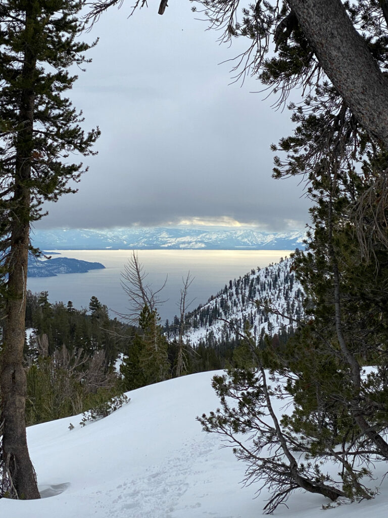
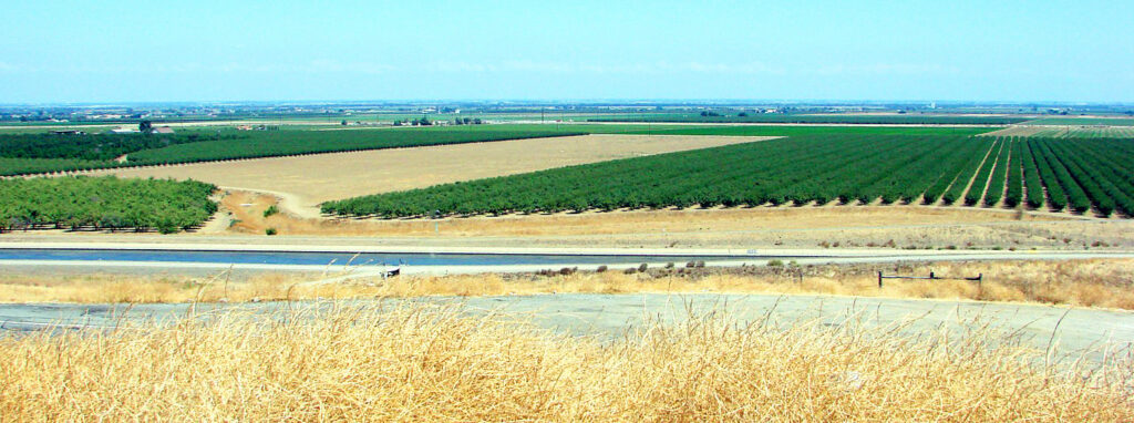
Lake Tahoe, pictured here, contains 37 trillion gallons of water, roughly half of which is supplied by snowmelt in the Sierra Nevada Mountains. Credit: Beatrice L. Gordon
Working at this scale, we found one-size-fits-all strategies often don’t hold up, even within the same hydrologic basin [Gordon et al., 2024; Boisramé et al., 2026]. In the Upper Colorado River Basin, for example, expanding reservoir storage could buffer agriculture in northeastern Utah against declining snowpack, but the same strategy may fail miles away in southwestern Wyoming, where a thirstier atmosphere may make it harder to refill existing reservoirs.
However, collecting detailed local-scale information for just 13 of the roughly 2,600 operational contexts nationwide took almost 3 years of searching websites, reading working papers, and calling water managers.
Scaling this approach across the entire western United States is understandably overwhelming. We need a more systematic approach to help managers identify which strategies could work most effectively, and where.
A Diagnostic for Agriculture and Snow Loss
Ostrom [2007] argued that complex systems, such as Western agriculture, “are partially decomposable in their structure.” This insight is woven into archetype analysis, an approach for identifying recurrent patterns across otherwise diverse systems.
Like workplace assessments—which are genuinely useful, albeit imperfect, tools for understanding successful management styles—archetypes draw on qualitative, quantitative, or hybrid approaches to group diverse operational contexts on the basis of shared characteristics [Sietz et al., 2019]. These groupings enable systematic knowledge transfer about, for example, how management strategies that work in one context can also guide adaptation elsewhere.
Three main characteristics interact to define operational contexts in snow-dependent agriculture in the western United States: physical constraints, governance systems, and human behavior.
“Researchers can empirically derive building blocks or components that comprise archetypes to represent key features of a system,” explains Elizabeth Koebele, who studies urban water sustainability [Garcia et al., 2019] and has begun applying archetypes in that context. However, she notes, these building blocks “vary based on the system context, available data, and study goal.”
We propose three main characteristics that interact to define operational contexts in snow-dependent agriculture in the western United States: physical constraints, governance systems, and human behavior. Physical constraints, including biophysical setting, infrastructure, and climate, determine available water supplies. Governance capacity relative to governance complexity shapes how those supplies are allocated across competing uses. Human behaviors influence both water demand and how users respond to supply conditions and governance rules.
Using these characteristics to establish archetypes of water management contexts could define a path forward for operationalizing an approach to accelerate successful adaptations to declining snowpacks in the West.
Constraining How Snowmelt Becomes Water Supply
Physical constraints stem from biophysical processes that influence how, when, and how much snow becomes streamflow; infrastructure that stores and conveys water; and hydrologic and climatic uncertainties about future supplies. These constraints can vary substantially from basin to basin.
Consider the Walker River Basin and California’s San Joaquin Valley, both of which rely on Sierra Nevada snowpack but have different biophysical settings. In some parts of the central Sierra, forest management can reduce wildfire risk and increase streamflow by up to 14% during low-snow years. Elsewhere, however, water made available by forest management may be consumed by remaining vegetation, limiting downstream gains.
These biophysical differences interact with uses of built infrastructure, including irrigation systems, reservoir outlets, and canals, to determine how and when water is stored and released. As temperatures warm and snowmelt declines, officials in both the Walker River and San Joaquin Valley basins must increasingly manage for a wider range of extremes, including “cold-water droughts.” However, the infrastructure to manage these trade-offs through reservoir storage and operations that balance agricultural deliveries with aquatic habitat needs is more developed in the highly managed San Joaquin than in the Walker.
Thankfully, measuring physical constraints on snowmelt at basin scales is becoming more feasible today with newly developed tools.
Layered on top of biophysical and infrastructural constraints are climatic and hydrological uncertainties, such as whether snow loss will lead to more evapotranspiration and less streamflow. These uncertainties complicate management decisions based on cost-benefit modeling of individual strategies: Should districts expand reservoir storage if precipitation is predicted to increase or decrease depending on the model? Frameworks like Decision Making Under Deep Uncertainty emphasize the need to select strategies that are robust across many possible futures.
Thankfully, measuring physical constraints on snowmelt at basin scales—a means, along with improved modeling, to reduce hydroclimatic uncertainties—is becoming more feasible today with newly developed tools. Water managers can turn, for example, to databases like the U.S. Geological Survey’s ResOpsUS [Steyaert et al., 2022], which catalogs historical reservoir operations across the contiguous United States, and to publicly available hydrologic projections such as those from Oak Ridge National Laboratory’s Coupled Models Intercomparison Project phase 6 (CMIP6) ensemble.
Governance Controls Supply Allocations
We frame governance around capacity and complexity. Capacity in this context is the ability of stakeholders “to mobilize resources in order to make equitable and fair decisions around shared challenges,” according to governance scholar Gina Gilson. Complexity refers to the number and intricacy of jurisdictions, authorities, regulations, and stakeholders involved. As governance complexity increases, the effectiveness of adaptation strategies becomes more sensitive to capacity constraints, particularly regarding timescales and funding.
For example, infrastructure in the Walker is controlled locally by a single water district, and jurisdictional coordination involves two states and the Walker River Paiute Tribe. Coordination on water management is never simple, but fewer jurisdictions generally means faster decisionmaking and clearer authority, allowing the single water district to implement strategies like multibenefit land repurposing more readily. Such implementations, in turn, enable reduced agricultural water use, directly supporting restoration of Walker Lake and recovery of endangered species.
The San Joaquin Valley is vastly different in scale and complexity, covering eight California counties, one of which alone has 22 water districts and seven cities. Following the passage of the state’s Sustainable Groundwater Management Act, water users in the basin formed more than 120 groundwater sustainability agencies. Agricultural water management thus involves overlapping federal and state systems that operate under different rules, contracts, and regulatory requirements. Whileland repurposing programs can be implemented, more substantial capacity, time, and resources are typically needed to do so.
Emerging efforts like the Western States Water Data Access and Analysis Tool (WestDAAT) and the Harmonized Database of Western U.S. Water Rights make it easier to assess governance in a basin by standardizing data about rules, regulations, and water rights across states. Combined with mapping of irrigation service areas and water transfers [Siddik et al., 2023], these resources help stakeholders identify the jurisdictions involved, how authority is distributed, and what coordination mechanisms exist for agricultural water management.
Human Behavior Shapes Demand Responses
Once snowmelt reaches water users, behavioral dynamics—how people respond to crises, policies, and changing conditions—determine how effectively management strategies achieve desired results.
Water demand is influenced by consumption choices and by economic, political, and cultural factors.
Water demand is influenced by consumption choices and by economic, political, and cultural factors. It is also influenced by factors that typical hydrologic models rarely account for, including social structure, social memory, and affluence. More affluent users are less likely to modify their behavior to reduce water use under conditions of scarcity.
The dynamics of water demand in the South Platte River Basin, for example, are especially complex, as they are balanced across cities, agriculture, and ecosystems across parts of Colorado, Nebraska, and Wyoming. Water prices in the basin’s Big Thompson project, a federal water diversion system in northern Colorado, jumped from $1,500 per acre-foot in 1990 to more than $30,000 in 2018, driven by economic factors that resulted in cities owning 70% of water originally intended for agriculture.
Even with reliable projections of future climate and water supply, carefully planned strategies can be overwhelmed by economic and behavioral factors, resulting in transfers and reallocations of water. What’s more, behavioral responses to adaptation strategies can paradoxically increase demand when users perceive that scarcity problems are solved.
The “reservoir effect” occurs when water security perceptions encourage expansion of water-intensive activities [Di Baldassarre et al., 2018]. Similarly, the irrigation efficiency paradox shows how efficiency gains can lead to expanded production and reduced return flows (how much irrigation water returns to streams and aquifers) downstream [Grafton et al., 2018].
Conceptual frameworks, models, and global case studies have all been used as approaches to study the effects of human behavior on hydrology. With sufficient training data, we believe tools like machine learning could be used to further explore how behaviors influence adaptation and to anticipate shifts as snow loss continues.
Archetypes in Practice
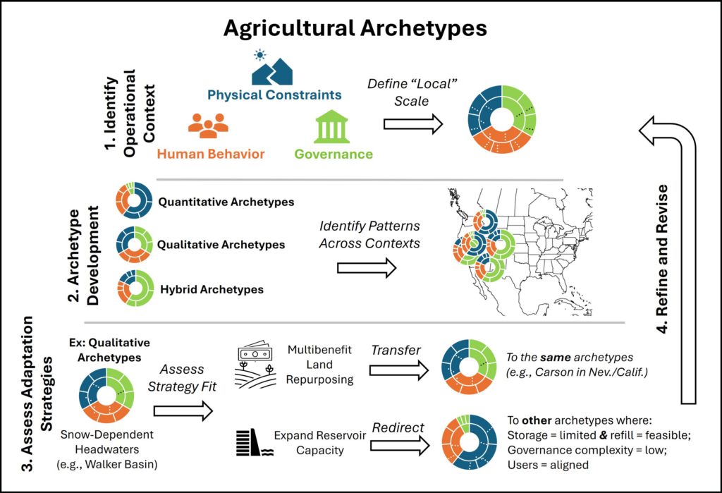
By evaluating how physical factors, governance systems, and human behavior shape outcomes across places like the Walker, South Platte, and San Joaquin basins, researchers and practitioners can establish archetypes to help identify patterns in what strategies are most effective in different places and assess how to transfer lessons from one setting to another (Figure 2).
Fig. 2. An archetype-based diagnostic grounded in evaluating the physical constraints, governance, and human behavioral dynamics affecting hydrologic basins could facilitate more rapid transfer of learning about successful adaptation approaches across snowmelt-dependent agriculture in the western United States.
The Walker River Basin exemplifies an archetype common to agriculturally dominated headwaters in the western United States with low governance complexity (few jurisdictions), adequate capacity (resources), low behavioral complexity (more predictable and unified user groups), and substantial physical constraints (significant future snow loss and limited infrastructure for water storage and supplementation).
With this profile, the Walker is an ideal testing ground for evaluating how effectively different strategies offset changes in snowmelt. Does cloud seeding increase snowpack? Could beaver dam analogues—a nature-based solution reminiscent of Idaho Fish and Game’s mid-20th century effort to parachute beavers into the wilderness—meaningfully increase water retention? Could multibenefit land repurposing buffer people and ecosystems against supply volatility while restoring ecosystem functionality?
The value of organizing operational contexts by archetypes is that each context need not be treated as unique.
The value of organizing operational contexts by archetypes is that each context need not be treated as unique. Lessons learned from the Walker could be systematically transferred to other areas with similar characteristics and could be incrementally tested in others.
The South Platte has physical constraints similar to Walker’s but features greater governance complexity because of multiple interstate compacts, as well as greater behavioral complexity. Modeling analyses indicate that demand-side strategies could adapt to more volatile water supply in the South Platte [Gharib et al., 2023]. But implementing them requires balancing perspectives from both agricultural and urban water users—a behavioral dynamic absent in Walker.
Crop switching to cultivate higher-value crops on less acreage could reduce water use. However, options for what crops can be grown where are constrained by factors like elevation and climate. Even where feasible, new crops would require investments in education, new infrastructure, risk management, and agronomic knowledge.
Through iterative expansion and testing, broad archetypes like “high behavioral complexity” could be specified to reflect dynamics like rural-urban competition or concerns around buy-and-dry economics. Archetypes may also point to contexts where governance complexity signals that decisionmaking is occurring above the lowest appropriate level.
The San Joaquin, with its extremely complex governance involving numerous local, state, and federal agencies managing surface and groundwater, is one potential example. Recognizing this pattern can help identify where substantial resources and long timelines may be required to implement programs (e.g., LandFlex) requiring legislative authorization, multiagency coordination, and stakeholder engagement. It may also signal the need to identify smaller operational contexts within larger settings so implementations proceed more rapidly.
Operationalizing Archetypes from Diagnosis to Action
Developing a systematic approach to match adaptation strategies with areas where they are most likely to succeed in operation is only a first step. Applying diagnostics without mechanisms to implement new strategies is often insufficient to drive timely action.
An instructive precedent of success in water quality management comes from the 1970s. By then, pollution controls on factories had improved compared with the early 20th century, yet water quality in surface waters across the country still declined because of pollution in agricultural runoff. The breakthrough came with the EPA’s total maximum daily load (TMDL) program, which created a structured process that set measurable goals for reducing pollution and assigned responsibility for meeting those goals to the sources of the pollution, allowing for local control over adaptation.
Archetypes could play a similar role in facilitating beneficial snow-loss adaptations, and a structure like the TMDL program could start by assessing supply-demand risks across operational areas, setting performance targets such as reservoir reliability and shortage frequency, and then using the diagnostic to identify which strategies fit each archetype. Results and lessons could be shared region-wide, while implementation would remain locally driven.
This suggestion is, emphatically, not a prescription for specific policy mechanisms. But it serves as a reminder that—just as few of us engage with workplace assessments or change behavior on the basis of their results without organizational support—archetypes will need to be paired with implementation structures to translate diagnosis into action.
Beyond Silver Bullets
There is no single answer to our trillion-dollar question, but one path forward for sustaining complex Western ecosystems lies in developing archetypes of different types of basins.
Nearly 20 years ago, Ostrom [2007] warned against seeking panaceas for complex environmental problems. There is no silver bullet for snow loss or single answer to our trillion-dollar question, but one path forward for sustaining complex Western ecosystems lies in developing archetypes of different types of basins.
A small irrigation district, for example, wouldn’t need to independently test every strategy in Figure 1 or develop complex decision support tools when a similar archetype already evaluated which strategies work under comparable governance, behavioral, and physical conditions.
Critically, these archetypes can be developed and refined by managers and scientists to capture more nuanced realities. Physically constrained systems, for example, could include areas facing high future uncertainty or limited reservoir flexibility. Governance and behavioral dimensions could likewise evolve to represent contexts where subsidies lead to incoherent incentives or where cultural norms link water use to local identities and traditions.
Like workplace assessments, the goal isn’t to diminish unique personalities but to work with them more strategically. Archetypes can show where we don’t need to reinvent the wheel to adapt and where the wheel might need to be tweaked. By leveraging collective knowledge and learning across regions facing similar challenges, rather than crafting new solutions basin by basin, we can reduce the time and resources needed to implement equitable and sustainable adaptation solutions.
Acknowledgments
This work is supported by the National Science Foundation (NSF) under grants 1828902 and OIA-2148788. Where We Live is funded by a grant from NSF’s Established Program to Stimulate Competitive Research (EPSCoR) RII Track-2 program and features partnerships across the University of Idaho (award 2316126); the University of Nevada, Reno (award 2316127); and the University of South Carolina (award 2316128). Work was also supported by internal funds from the Division of Hydrologic Resources at the Desert Research Institute.
References
Boisramé, G. F., et al. (2026), Think globally, model locally: Complex responses of agricultural water supplies to different climate projections, J. Am. Water Resour. Assoc., 62(3), e70117, https://doi.org/10.1111/1752-1688.70117.
Garcia, M., et al. (2019), Towards urban water sustainability: Analyzing management transitions in Miami, Las Vegas, and Los Angeles, Global Environ. Change, 58, 101967, https://doi.org/10.1016/j.gloenvcha.2019.101967.
Gharib, A. A., et al. (2023), Assessment of vulnerability to water shortage in semi-arid river basins: The value of demand reduction and storage capacity, Sci. Total Environ., 871, 161964, https://doi.org/10.1016/j.scitotenv.2023.161964.
Gordon, B. L., et al. (2024), The essential role of local context in shaping risk and risk reduction strategies for snowmelt‐dependent irrigated agriculture, Earth’s Future, 12(6), e2024EF004577, https://doi.org/10.1029/2024EF004577.
Ostrom, E. (2007), A diagnostic approach for going beyond panaceas, Proc. Natl. Acad. Sci. U. S. A., 104(39), 15,181–15,187, https://doi.org/10.1073/pnas.0702288104.
Sietz, D., et al. (2019), Archetype analysis in sustainability research: Methodological portfolio and analytical frontiers, Ecol. Soc., 24(3), 34, www.jstor.org/stable/26796999.
Steyaert, J. C., et al. (2022), ResOpsUS, a dataset of historical reservoir operations in the contiguous United States, Sci. Data, 9, 34, https://doi.org/10.1038/s41597-022-01134-7.
Sturm, M., et al. (2017), Water and life from snow: A trillion dollar science question, Water Resour. Res., 53(5), 3,534–3,544, https://doi.org/10.1002/2017WR020840.
Author Information
Beatrice L. Gordon (beatrice.gordon@dri.edu), Gabrielle F. S. Boisrame, Christine M. Albano, and Rosemary W. H. Carroll, Desert Research Institute, Reno, Nev.; and Adrian A. Harpold, University of Nevada, Reno
Citation: Gordon, B. L., G. F. S. Boisrame, C. M. Albano, R. W. H. Carroll, and A. A. Harpold (2026), Archetypes could accelerate agricultural adaptation to less snowpack, Eos, 107, https://doi.org/10.1029/2026EO260184. Published on 9 June 2026.
This article does not represent the opinion of AGU, Eos, or any of its affiliates. It is solely the opinion of the author(s).